Ridiculous flooding
|
| |
 The Sorrento West Business Park runs
between Roselle Street, I-5, Flintkote and Estuary Way. The older parts
were built out in the 1960s. Occupants are primarily a collection of hi-tech
companies in leased buildings. This district flooded September 1997, January
1997 and November 1996. The Sorrento West Business Park runs
between Roselle Street, I-5, Flintkote and Estuary Way. The older parts
were built out in the 1960s. Occupants are primarily a collection of hi-tech
companies in leased buildings. This district flooded September 1997, January
1997 and November 1996.
Remember the famous floods of September
of '97? Probably not there weren't any in the rest of the city. However,
less than 1 inch of rain caused Roselle Street to flood with two feet of
water, stranding motorists who had to be rescued from their trapped vehicles.
This event is called a 1-year rain
event, since this is the amount of rain you would expect every year. In
1995, rains equivalent to a 10-year event (an event expected to occur an
average of once every 10 years - you get the idea) considered a moderate
rain event caused serious flooding in the interiors of buildings. The resulting
damage cost flooded businesses millions of dollars. One company went out
of business and is suing the City for not preventing the flooding.
Rail transportation was halted through
the area because of the flooding. Auto traffic had to be rerouted from one
of the busiest intersections in the city. The railroad tracks are often
under water during the bigger events, requiring a railroad person to walk
in front of the trains to be sure the bridges over the creek are still there!
Flooding during light rain events
such as those of this past year is ridiculous. Why is it happening? Four
factors are at cause: bad land use decisions, urbanization of the watershed,
channelization, and lack of maintenance. All contribute to the history of
flooding in this area. |
Problem #1: Flood plain development
|
| |
To put it simply, the Sorrento West
Business Park was built in a flood plain. Poor land use decisions by the
City of San Diego allowed building in this flood plain (and others, such
as the Tijuana River Valley).
Legally, the City justifies permitting
this building by saying that these flood plains weren't officially mapped
by the Army Corps of Engineers (ACOE) or the Federal Emergency Management
Agency. This is technically true: the ACOE didn't officially map the area
until 1967. The maps show the "intermediate regional flood" (100-year
flood) and the "lesser flood" (50-year flood) areas for Soledad
Canyon, Carmel Valley, Los Peñasquitos Creek, Poway Creek, Rattlesnake
Creek, and Pomerado Valley, the watershed of Los Peñasquitos Lagoon.
Truly, determining the extent of
the flood plain can sometimes be difficult. However, this is not the case
in Sorrento Valley. City planners had to know they were permitting development
in a flood-prone plain. After publication of the ACOE report, some of the
future developments were required to build on higher pads, theoretically
lifting them out of the flood plain. However, the streets surrounding them
were still below flood plain level, leaving buildings surrounded by floodwaters
.
Even back in 1967, ACOE noted that
floodwaters overtop the channels and cause damage to residential and commercial
development or to property suitable for such development. "The existing
flood-control works in Los Peñasquitos area are inadequate for large
flows." The report noted that these conditions existed for all six
of the creeks they studied in the drainage area. |
Problem #2: Urbanization
|
| |
The ACOE report was prompted by a
request from the City of San Diego, as planners looked at the plans for
future development, i.e., urbanization of the watershed. Ironically, in
1967, it was the City of Poway that was undergoing the rapid development,
while development in Mira Mesa and Carmel Valley was still a gleam in developers'
eyes.
Urbanization has a big impact on
a watershed. As you convert natural lands or agricultural lands to rooftops,
parking lots and streets (impervious surfaces), you reduce the capacity
of a watershed to absorb water. The resulting runoff is carried via storm
drains into our canyons not into our sewer system and safely out to the
ocean as many people assume. As urbanization progresses, the water flow
into the canyons far exceeds historic levels.
One impact is an increase in peak
flood flows. Prestegaard estimated that the 2-year flood volume would double
on major streams, and increase by four times on urbanized tributary streams.
Similarly, a 100-year flood volume would increase by 1.3 times on major
streams and by 3 times on tributaries (Prestegaard 1975). In the same report,
Prestegaard studied the channels throughout the watershed and stated unequivocally
that, "The channel in Soledad Valley [the old name for Sorrento Valley]
cannot contain any but the lowest flows."
A 1992 San Diego Association of Governments
(SANDAG) report came to similar conclusions. This report also predicted
that the Sorrento Creek channelization could carry only a 15-year flood
peak event with urban development in place. Other impacts expected from
urbanization in our drainage have been well studied and include: increased
erosion (especially during the construction phase), increased sediment load
and declining water quality due to pollution in urban runoff pollution. |
Problem #3: Channelization
|
| |
So, we not only have buildings directly
in the flood plain throughout all of the creeks in the watershed, but we
also have large-scale urbanization that increases the volume and frequency
of flooding. Historically, the reaction to this threat has been to dam,
dike and channelize our rivers and streams, whether a flow is as large as
the Mississippi or as small as Peñasquitos Creek and its tributaries.
All of this has been done to these creeks.
The idea is to take the natural stream
beds and deepen them, widen them and, often, line them with concrete or
rip rap (large rocks). Sometimes, the entire stream bed is put inside a
culvert to carry the water out to the ocean fast. This works in many cases
if you build it big enough for your biggest flood event, maintain the dikes
or channel walls, and keep them clean of debris, silt and vegetation. Ironically,
such channelization is often done on a piecemeal basis, as is the case in
our drainage.
Many of the tributaries in the City
of Poway that feed Peñasquitos Creek are channelized. This sends
more water downstream faster, increasing peak flows and the tendency to
flood! It's a way of exporting your flooding problem downstream. (A San
Diego city engineer recently complained in a meeting I attended that it
was impossible to get the City of Poway to return calls on this subject.) |
Problem #4: Maintenance
|
| |
Our fourth and last factor is the
lack of maintenance. As with many other things in our city (e.g., sewers,
roads), maintenance of channels is often the first thing to be cut in the
City budget, deferred to the "future." The result is crisis management.
The channels approaching and in Sorrento Valley were inadequately maintained
for decades. Silt carried by the increased erosion due to urbanization in
the watershed built up to a depth of 12 feet in some areas. This new land
was colonized by native and exotic plants such as arundo donax (giant
reed). The latter is well-known for clogging channels. The buildup of vegetation,
in turn, traps more sediment and slows down flood waters just where they
were meant to pass quickly. Flooding increases.
The lack of maintenance also meant
that storm drains from Roselle Street that emptied into Sorrento Creek were
blocked by the silt buildup. The result: flooding in light to moderate rain
events. The water in Sorrento Valley literally had no place to go and created
a lake during each moderate rainfall. |
Environmental concerns
|
| |
The Friends of Peñasquitos
Canyon have two sets of concerns connected to this flooding and attempts
to correct it. First, the only wildlife corridor connection from Torrey
Pines State Park to the outside natural world in this case, Peñasquitos
Canyon Preserve is along Peñasquitos Creek, from its junction with
Sorrento Creek upstream under the I-5/I-805 merge. This connection is vital
for the biological health of the wildlife in both parks. Bulldozing these
creeks will adversely impact this connection.
In meetings with other environmental
groups (Audubon, Surfrider), Sorrento West businesses, State Parks and City
Engineering, the Friends pushed to save the wildlife corridor connection
by reducing the proposed bulldozing. Originally, the City proposed a new
pilot channel to the ocean that would be 200 feet wide in Sorrento Valley.
This would have destroyed the wildlife linkage. Facing stiff opposition
from many quarters, the City brought forward a new plan calling for a 100-foot-wide
channel in Sorrento Creek. This new plan leaves an adequate, heavily vegetated
corridor along the natural creek to the east.
It's my opinion, shared by the Friend's
Tracking Team/Wildlife Survey leader and a wildlife biologist who just completed
a study for the State Park, that the bulldozing of the bottom of Peñasquitos
Creek, lowering the silt level and reducing the cattail density, can actually
improve wildlife movement through that portion of the creek. Currently,
the high silt and vegetation buildup, especially the arundo donax,
blocks wildlife movement in the area. The key is maintaining brush cover
on the two banks for the wildlife.
Second, we are concerned with the
impacts of urbanization in both Parks. Erosion is a serious problem in Peñasquitos
Canyon, threatening already endangered plants (monardella linoides viminea)
and wiping out all vegetation in portions of drainages (especially López
Canyon). Increased flows and erosion are causing accelerated incising of
the creek, with headward erosion and dewatering of the associated wetlands.
Erosion also means too much silt
gets carried downstream where it clogs the channels, as well as causing
a buildup in Peñasquitos Lagoon, creating upland habitat in place
of saltwater marsh. Runoff pollution from development ringing the Preserve
reduces our water quality to "fair" in water quality testing the
Friends and various agencies have conducted. For instance, too many nutrients
and too much nitrogen and phosphorus in the water promotes a buildup of
algae and "algal blooms," to the detriment of fish and benthic
organisms.
This situation is exacerbated by
the inadequate tidal flushing in the lagoon, due to the closing of the mouth
of the lagoon by various highways and bridges crossing it. With the mouth
closed and too many nutrients and consequent algal blooms the lagoon can
quickly deplete its oxygen, leading to kill-offs of its fish and mollusk
populations. This, in turn, effects the bird populations that depend on
the lagoon for their food.
Urbanization also means more fresh
water all year, as well as during storm events, leading to a buildup of
freshwater habitat at the expense of salt marsh in Peñasquitos Lagoon.
Salt marsh habitat is rarer and is a priority for preservation. |
A brief history: a creek by any other name ...
|
| |
Sorrento Valley and Sorrento Creek
are new names. Until the 1960s, they were Soledad Valley and Soledad Creek.
There is still a Soledad Canyon in the southern (upper) portion of Sorrento
Valley. It is now only a major finger canyon, running northwest to southeast
off Carroll Canyon, carrying the Santa Fe Railroad under Miramar Road and
across the Marine Air Station. (It's a beautiful canyon, with some of San
Diego's oldest coast live oaks, good habitat, mule deer, hawks, etc. It's
also a good wildlife corridor. You can access it off of Carroll Road at
Scranton.)
Peñasquitos Creek once referred
to the entire length of the creek, from the foothills of Poway all the way
into Soledad Valley. Now, the upper portion in Poway is called Poway Creek. |
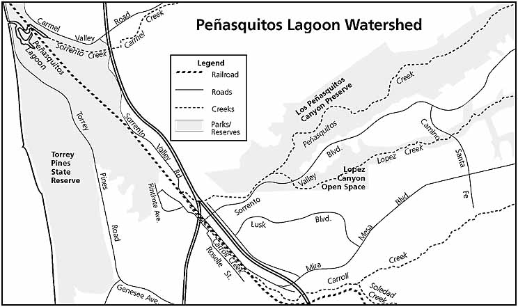
Watersheds
|
| |
Webster's defines "watershed"
as "the area drained by a river or river system." The watershed
that drains into Peñasquitos Lagoon ranges from 95 sq. mi. (ACOE,
1967) to 98 sq. mi. (Prestegaard 1975), depending on whose estimate you
use. It includes the drainages of Carmel Valley, Carroll Canyon and Los
Peñasquitos Canyon (Peñasquitos Canyon reaches all the way
up into Poway).
The Peñasquitos drainage or
sub-watershed is the largest of the three, being about 58 sq. mi. The major
creeks or tributaries flowing in these drainages include Deer Canyon Creek,
which flows into Carmel Creek in Carmel Valley; Carroll Creek; and Pomerado,
Rattlesnake, and Beeler Creeks which all flow into Poway Creek, which becomes
Peñasquitos Creek. |
The insults begin
|
| |
I use insults here as both a technical
term for negative impacts on the land and water, and as a pejorative.
The first major insult to Peñasquitos
Lagoon occurred with the building of the railroad in about 1888. This began
the process of closing the lagoon mouth to the influence of the tides that
are necessary to maintain it as a healthy salt water-dominated water and
marsh habitat.
Ellis and Lee reported in 1919 that
the "Soledad Streams" were able to keep narrow channels open through
the beach, at least during part of the year. However, the building of Highway
101 across the lagoon in 1932 worsened the situation. The lagoon began to
be closed most of the time, causing a die-off of saltwater-dependent organisms
and vegetation and a shift in the types of vegetation present. For example,
no living mollusk species were found in several studies in the 1960s. Only
during exceptionally wet winters could sufficient freshwater collect to
break through the barrier bar that develops in the lagoon mouth. |
Sewage flows in creek and lagoon
|
| |
In the 1980s, our daily paper often
treated us to news of sewage spills from the infamous pump station in Peñasquitos
Lagoon, closing beaches and promoting organism die-offs. However, what most
people don't know is that treated sewage (the PR term is "treated effluent")
was intentionally pumped into the Lagoon for decades.
The Callan Treatment plant, an old
WWII facility located on Torrey Pines Mesa, was reactivated in the 1950s
and began pumping 50,000 gallons of treated effluent per day into Soledad
Creek and the lagoon. It was joined in 1962 by the Sorrento plant, which
was pumping about 500,000 gallons per day into the same lagoon. Another
facility, the Pomerado Waste Water Treatment Plant, pumped even more treated
sewage into Peñasquitos Creek from 1962 to 1972.
In addition, the Peñasquitos
Settling Ponds were used for sewage treatment, perhaps as late as 1967;
I have yet to find a good report on these. These ponds may still be seen,
vegetated now, just west of the Rancho Santa Maria ranch house off Black
Mountain Road. These 14 acres of dikes and ponds sit right next to Peñasquitos
Creek. What we don't yet know is if any of this effluent was pumped or leaked
into the creek. (This is an area the Friends hope to restore soon.) Many
folks living downstream during this period, in Mira Mesa and Rancho Peñasquitos,
had no idea the stream they were visiting and their kids were playing in
was in large part treated sewage!
Plans for an SDGE Nuclear Power Plant
in Sorrento Valley and for a new Pomerado Water Reclamation Plant with live
stream discharge were both discarded. Public opposition played a big role
in both decisions. |
"Effluent" impacts on lagoon
|
| |
The discharge of treated effluent
brought two problems with it. One was fresh water flows into the lagoon
that were way above the historic levels, particularly outside of the rainy
season. This effluent flow occurred during a time when urbanization was
also adding fresh water to the system, not just during storm events, but
all year long due to irrigation.
The second problem was the high nitrate
and phosphate levels of the effluent. This combination of additional nutrient-rich
fresh water pouring into a closed lagoon system without adequate tidal flushing
led to repeated die-offs and the shift in vegetation types. Elevated temperatures
occur up in the waters of a closed system like this, and contribute to the
die-offs. Such a die-off occurred in San Elijo Lagoon in the summer of 1997.
Another problem caused by this infusion
of effluent was a tremendous mosquito problem. This prompted significant
public opposition to these flows and, combined with studies of the negative
biological impacts, led the Regional Water Quality Control Board to oppose
continuation of these existing facilities or the building of new ones.
Peñasquitos Lagoon's mouth
is now kept open with periodic and expensive bulldozing but it accomplishes
its purpose of permitting tidal flushing. |
Impacts on Peñasquitos Creek
|
| |
Peñasquitos Creek is now a
perennial creek, flowing year round. Was this always the case? Firsthand
observations by various individuals, plus U.S. Geological Survey data for
the creek starting in 1964, indicate that the creek wasn't consistently
perennial. In years with above average rainfalls, heavy late seasonal rainfalls
or significant summer rain, the creek flowed to the lagoon throughout the
year. During years of average to low rain flows, certainly during periods
of extended drought, it was seasonal. This shouldn't be surprising in our
arid climate.
The flow data we do have (on the
web at www.usgs.gov) illustrates the impact of the live stream discharge
between 1962-1972. From 1965-1972, the median discharge of treated effluent
was .90 cfs (cubic feet per second), ranging from a low of .03 cfs to a
high of 3.50 cfs. It also showed a sharp drop when the plant closed in 1972.
From 1973-1979, the median discharge dropped to a low of 0.10 cfs, with
a range of 0.00 to 25 cfs. In other words, at times, there was no measurable
flow in the creek. Thereafter, the median discharge steadily increased,
even during the summer months, probably reflecting increased runoff due
to urbanization in the watershed.
The natural springs feeding Peñasquitos
Creek are too few and far between to promote a year round flow, except in
their immediate downstream areas. The largest natural spring pumps up to
86,000 gallons per day into the creek. If you were standing downstream of
one of these springs, the creek would certainly be flowing past you at any
given time, probably, but not all the way to the ocean. If you were standing
downstream in the lagoon during the period of 1950-1972, you would have
been seeing a flow but mostly of treated effluent.
Now, however, we have a strong year-round
flow, even during the most recent drought, due to irrigation, car washing,
etc.. Is this additional flow good or bad? These flows do tend to bring
toxics (oil from driveways), pesticides and fertilizer all harmful to some
extent to the water and the organisms in it. However, each significant finger
canyon in the Preserve now has a new riparian area in it: this is both good
and bad. Riparian areas in the desert tend to be scarce, but extremely important
to wildlife. Adding some small acreages is beneficial. On the negative side,
this same runoff brings seeds of exotic plants, which tend to have a negative
impact on local flora and fauna. The Friends are spending considerable energies
clearing these exotics out of these same canyons. Constant management can
control the exotics.
The worst impact from urbanization,
I feel, is the increase in peak flow and velocity during storms. We are
seeing much more erosion, areas that are denuded and remain so, and beds
of cobble or bedrock with no vegetation. The Friends are still grappling
with how to mitigate this problem. |
Mitigation
|
| |
When their projects impact salt marsh
and fresh water riparian areas, the City is required to mitigate by restoring
or creating similar habitat elsewhere. As mitigation for the creek bulldozing,
a proposal to remove old dikes, restoring the historic flood plain, was
accepted, and restoring wetlands was tentatively accepted. This is the area
we call the "bean fields," north and east of the El Cuervo adobe
ruins at the Sorrento Valley end of the Preserve. Detailed analysis and
plans are being worked up. We wanted this proposal to emphasize the need
for upstream solutions - where the problems originate - and solutions that
deal with the underlying causes of the flooding and the negative impacts
on the lagoon. |
City stonewalling
|
 |
In the meetings with the City Engineering
Dept., The Friends and others emphasized the importance of looking at the
flooding and other problems we have identified as watershed problems. We
argued for upstream solutions to reduce the siltation and peak flows that
cause downstream problems. We argued that this would be safer and cheaper
for the taxpayers in the long run, in place of the crisis management of
the past.
Unfortunately, we did not feel that
the City was responsive to this perspective, in any way. We will keep pushing
this perspective. It's the right thing to do. 
Reprinted from Canyon News, the newsletter of the Friends of Los Peñasquitos
Canyon Preserve, Inc., with permission. To find out about memberships, call
(619) 484-3219 or (619) 566-6489. To find out about volunteering to help
with their ongoing preservation and restoration projects, call 619) 224-4192. |